.png)

Stream Monitoring
Established in 2014, our Stream Monitoring program uses a volunteers workforce to collect water samples from multiple sites at each stream, several times each season. Sites are carefully selected on each stream to better identify the sources of high pollutant levels. Sampling during high flow storm events is difficult, but very important due to the high levels of pollutants that occur during these times. High pollutant levels, coupled with high flow into the lake, make these events a key contributor to the pollution of Seneca Lake. Overall, the stream monitoring program has shown that: Trends show that streams have E. coli counts above the recreational limit at base flow. However, there are extraordinary rises in E. coli counts at time of high flows, by a factor of as much as 100. High E. coli counts point to the presence of significant sources of untreated animal and/or human waste that is readily mobilized in runoff. Dissolved (mostly bioavailable) phosphorus concentrations average roughly 2x to 3x higher in Seneca Lake streams than in Cayuga Lake streams. High phosphorus levels are broadly correlated with increased HABs in freshwater lakes. Shoreline concentrations of dissolved Phosphorus are likely to be elevated near the mouths of many streams. Total nitrogen concentrations are elevated in predominantly agricultural areas. | Read last years Annual Report for most current stream sampling summaries Visit the Community Science Institute (CSI) webpage for most up-to-date stream sampling data |
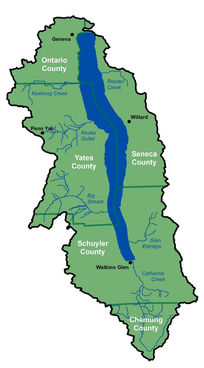
| Seneca Lake has six larger streams that impact water quality the most. Reeder Creek has its origins in the former Seneca Army Depot and flows north then west into Seneca Lake just north of Sampson State Park. Reeder Creek watershed is made up of 60% forest and 31% agriculture, with a wetland area at its source. Kashong Creek flows into the west shore of Seneca Lake about seven miles south of Geneva. It has a relatively large watershed area that makes up approximately 6% of the total Seneca Lake watershed area. Its watershed is roughly 83% agriculture and 15% forested land, and includes only very minimal residential or urban areas. Keuka Outlet is the largest tributary to Seneca Lake, with its watershed area representing 35% of the Lake's total area. It is the sole outlet of Keuka Lake, and flows northeast from Penn Yan to Dresden, on the central western shore of Seneca Lake. Flow from Keuka Lake is controlled by gates in a dam at Penn Yan. The drainage area into the outlet, not including Keuka Lake, is 79% agriculture and 16% forested land. The outlet has a long history of mills and other industry on its shores, and has historically functioned as a canal for water transport between the two lakes. Big Stream flows into the west shore of Seneca Lake at Glenora Point. It has a relatively large watershed that makes up approximately 7% of the total Seneca Lake watershed area. Its watershed is roughly 74% agriculture and 15% forested land, and it passes through the village of Dundee. Glen Eldridge is a small pristine stream on the southeast shore. Catharine Creek is one of the major tributaries to Seneca Lake, encompassing approximately 31% of the total Seneca Lake watershed area. It originates in the Horseheads, NY area and flows north, into the southern tip of the Lake. It is by far the longest Seneca Lake tributary, with this watershed consisting of 49% agriculture and 45% forested areas. |
Stream Monitoring |
Keep up with Pure Waters:
| Seneca Lake Pure Waters Association P.O. Box 247 Geneva, NY 14456 Email: info@senecalake.org Seneca Lake PURE WATERS Association Seneca Lake water quality for ALL who have the privilege of knowing it. |
|